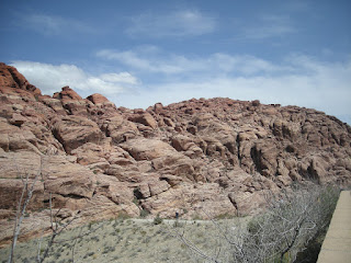
On March 25th, we toured the Red Rock Canyon in Nevada. It's about 60 miles west of Las Vegas. The red rock formations in the area are very picturesque. The area is populated by wild burrows, and wild horses. we did encounter two wild burrows, but couldn't get the camera out in time to take a picture. See some of our photos:


Red Rock Canyon


Red Rock Canyon National Conservation Area in Nevada is an area managed by the Bureau of Land Management as part of its National Landscape Conservation System, and protected as a National Conservation Area. It is located about 15 miles (24 km) west of Las Vegas, and easily seen from the Las Vegas Strip. The area is visited by over 1 million visitors each year.


La Madre Mountain seen from Griffith Peak
The conservation area showcases a set of large red rock formations: a set of sandstone peaks and walls called the Keystone Thrust. The walls are up to 3,000 feet (910 m) high, making them a popular hiking and rock climbing destination. The highest point is La Madre Mountain, at 8,154 feet (2,485 m).
A one-way loop road, 13 miles (21 km) long, provides vehicle access to many of the features in the area. Several side roads and parking areas allow access to many of the trails located in the area. A visitor center is located at the start of the loop road. The loop road is very popular for bicycle touring; it begins with a moderate climb, then is mostly downhill or flat.


Red Rock Canyon itself is a side-canyon accessible only by four-wheel-drive road off of the scenic loop. The unnamed but often visited valley cut through by State Route 159 is commonly, but incorrectly, referred to as Red Rock Canyon. The massive wall of rock called the Wilson Cliffs, or Keystone Thrust, can be seen to the west along this highway.
Towards the southern end of the National Conservation Area are Spring Mountain Ranch State Park, the western ghost town replica attraction of Bonnie Springs, and the village of Blue Diamond. The conservation area is one of the easternmost parts of the Mojave Desert; the lowest elevation of the area, from 3,600 to 4,500 feet (1,100 to 1,400 m), is in the Lower Sonoran Zone, while the area from 4,500 feet (1,400 m) up is in the Upper Sonoran Zone. The character of the sandstone layers is such that a number of year-round springs may be found in the recesses of the side canyons.
Some 600 species of plants are known in the area. Common types in the valley floor include the Joshua tree, Mojave yucca, banana yucca, creosote, and blackbrush. Higher up the Utah juniper and Sonoran scrub oak. (also called scrub live oak) come to dominate. Agave is easy to spot in red rock niches, with its thick low leaves and flowering stem that reaches twice the height of a man. The Calico Tanks trail has a plaque about prehistoric agave roasting pits. Ponderosa pines may be found at the top of the valley, where it connects to the Spring Mountains.
Wild burros are a familiar sight, as are rabbits and ground squirrels. Desert bighorn sheep are occasionally seen at higher elevations. During rare spring and summer rainstorms, tiny red-spotted toads can be seen emerging from pools of water.
The Conservation Area is protected habitat for the Desert Tortoise. A mascot tortoise, named Mojave Max, was kept at the Visitors Center. The Las Vegas Review-Journal reported on July 2, 2008 that Max had died of natural causes at the age of 65. A successor has not been named.
An outcrop of Aztec Sandstone
The Red Rock Area has a complex geological history, which over millions of years, helped to create the dramatic landscape that characterizes the region.
The Red Rock area was located under a deep ocean basin during the Paleozoic Era 600 million years ago. Sediments up to 9,000 feet thick were deposited, and eventually lithified. This sediment eventually formed into limestone.
Calico Hills scenery in Red Rock Canyon
Sunset at Red Rock Canyon
Around the Mesozoic Era 250 million years ago, the earth's crust started to rise due to tectonic shifts, forcing the water out and leaving behind evaporite formations of salt and gypsum. Exposure of the former sea bed allowed some of the rocks to oxidize (literally rust) and formed the area's characteristic red and orange rock layers.
Eventually a lush plain with streams and trees developed in the area. Some of these trees were covered with mud from the streams and eventually became petrified wood. Many of these fossilized logs can still be found today at the base of the Wilson Cliffs.
By 180 million years ago, the climate continued to change and the area became a desert featuring vast expanses of huge shifting sand dunes. These dunes would pile up and were lithified, and are now called Aztec Sandstone. During a mountain building period called the Laramide orogeny around 65 million years ago, the Keystone Thrust Fault developed, which ran through most of North America and through the Red Rock Conservation Area. The movement of this fault forced the older grey sedimentary rock over the younger red rocks, forming the striking red line that can be seen in the mountain today.
No comments:
Post a Comment